The Surface Map’s render contains technical information used for calculating shadows and lighting. With some manipulation, this render can be very useful for problem-solving surface details and rigging.
The standard surface map renders a mapping that displays the X-position in fields in the red channel, the Y-position in fields in the green channel and the Z-position (elevation) in fields in the blue channel. The X and Y (red and green) coordinates are calculated automatically, but the Z values (blue channel) are provided by the defined ranges in the Surface Map and the attached Height Maps.
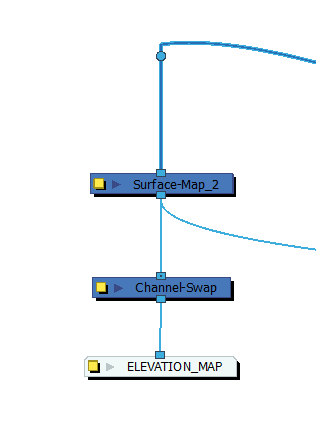
- In the Node Library view, in the Filter category, drag a Channel-Swap node to the Node View. Then, connect the output port of the Surface Map node to the Input Port of the Channel Swap node.
-
In the Node Library view, in the Output category, drag a Display node to the Node View. Then, connect the output port of the Channel Swap node to the input port of the Display node.
-
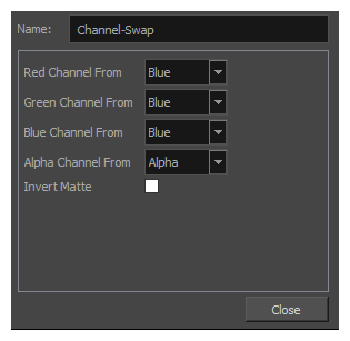
Click on the Layer Properties button for the Channel Swap node and, in the Layer Properties dialog, set Red Channel from, Green Channel from and Blue Channel from parameters to Blue.
-
In the Display toolbar, select the display connected to the Channel Swap node to visualize its output in the Camera view.
-
In the toolbar at the bottom of the Camera view, click on Render View to preview the elevation of the Surface Map node. The preview will be in greyscale, with higher values rendered as brighter greys than lower values.